A Minnesota aerial applicator did such a thorough job explaining the adverse effects a proposed wind energy project would have on aerial applicators and the farmers they serve in the affected area that his comments to a state official conducting an environmental review serve as an outstanding model for any aerial applicators grappling with infrastructure projects that could affect their ability to serve area farmers.
Ryan Lubben owns West Central Ag-Air Inc. in Fergus Falls, Minnesota, but has frequently spent time applying fungicides and insecticides on farms a few hours south of Fergus Falls in Dodge County, Minnesota. His comments to an environmental review manager at the Minnesota Department of Commerce systematically explain why the NextEra Energy Resources Dodge County Wind Project, as currently planned, would be incompatible with aerial applicators’ ability to safely provide services to farmers located within the wind project’s widespread footprint.
As an opening salvo, Lubben provided facts about the aerial application industry and his company’s operations, but then he went several steps further to highlight the importance of aerial application to farmers and clearly illustrate the unacceptable safety risks the densely clustered wind turbine project would present to aerial applicators. The comments came together rather quickly once he gathered a few Surety maps and overlayed his GPS logs onto them.
Before getting into the hazards of the proposed wind farm, Lubben gave examples of three reasons why growers need to retain the ability to use ag aircraft. The three reasons he cited were efficiency, economics and environmental benefits. For his economics example, Lubben wrote:
Growers in the area typically get an average of a 17 bushel increase in corn yield by applying a fungicide during the tassel stage of development. (Per conversation with a local grower) Using today’s cash corn price of $7.63/bushel, this equates to an increase of $129 per acre. My company would charge roughly $21/acre for this application including chemical. That translates to $108 per acre of profit for the farmer, or a 500% return on investment!
Lubben then moved into the “show” portion of his show-and-tell comments, using his own Surety maps and GPS logs to illustrate to the environmental review manager how the proposed wind turbine construction would jeopardize his and other aerial applicators’ ability to safely enter, exit and return to farmers’ fields in the areas surrounded by the wind turbine clusters and the associated transmission line.
Lubben included the map below of the Dodge County Wind Project area and explained that the GPS flight tracks from his operation for one season were overlaid onto it.
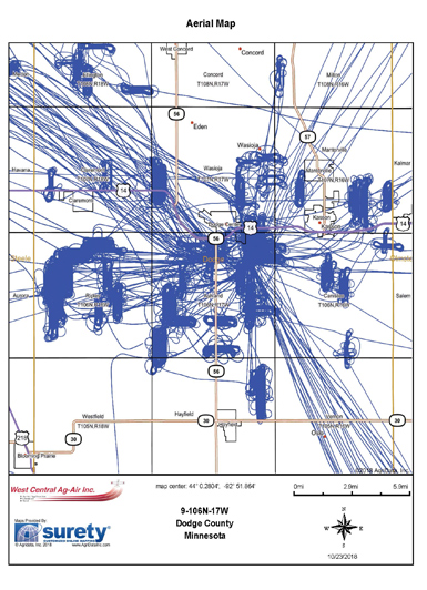
FIG. 1
Next, Lubben illustrated safe turnaround distances necessary to make aerial applications safely (see Fig. 2 below):
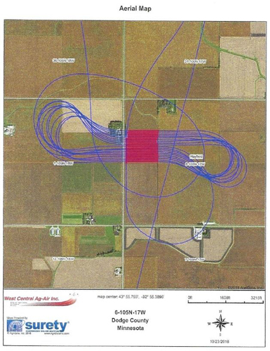
FIG. 2
This map shows the GPS flight tracks from a typical field being sprayed. The blue lines are the flight path and the red lines are the actual spray swaths.
As you can see, the aircraft needs quite a large area to have room in order
to turn around on the end of the field. In fact, most of the flying
takes place outside of the field being treated. The distance needed for
this particular aircraft is approximately ¾ of a mile. As a rule of
thumb, and [the] aircraft needs a full mile of distance on the end of the
field to make a safe turn around. Obstacle free turn around areas is
critical for these aircraft as the turnaround maneuver is when the
aircraft is quite slow and vulnerable to an aerodynamic stall. The
applicator must remain focused at this point and cannot be distracted by
obstacles, and must have ample room to make the maneuver.
Finally, Lubben included a map showing the proposed locations of the Dodge Center wind turbines in the western portion of the project area (see Fig. 3).
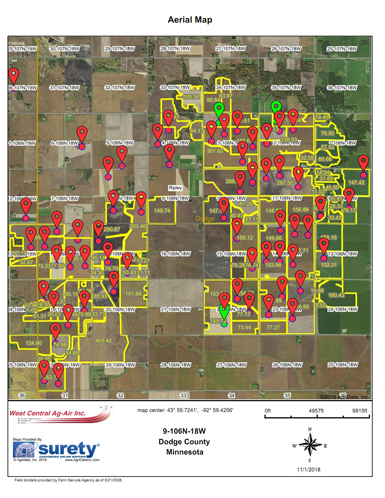
FIG. 3
Each red dot indicates a turbine location. I have highlighted the fields in
yellow which would not meet the criteria of having a one mile turn
around obstacle free zone on the end of the field. I estimate this map
to be a conservative representation of what fields cannot be serviced by
ag aircraft. … this is just a portion of the wind farm area. There will
be many more fields affected.
Clearly this proposed wind farm will have far reaching impacts on
growers in the area in regard to aerial application. Quite frankly the
density and random turbine layout will make it impossible for aerial
applicators to work safely. Furthermore, it may be impossible for
growers in the area to even entice an applicator to come in and do any
work in the larger area.
Lubben isn’t opposed to all wind turbine projects and has even had success working around another wind energy site not far from the proposed NextEra Energy Resources wind project. He closed his comments by pointing out the distinctions between the two wind projects:
The incredibly large scope and density of the Dodge County wind turbine
layout is what is the issue here. Changes can be made for the area to
keep aerial application while still producing wind power. A perfect
example of this is the McNeilus wind farm located just two miles south
of the Dodge Center airport. This wind farm has the towers lined up and
contained in a small area. I have actually been quite comfortable
spraying fields in this area because I know I can exit the turbine area
in a straight line and make my turn arounds outside of the wind farm.
This could easily be done in the proposed wind farm by orientating the
wind towers in groups or in straight lines and leaving a mile buffer
between groups or lines to allow room for aircraft turn arounds.
Lubben’s full comments are available here. NAAA commends Ryan for his sophisticated yet simplified explanation of the ramifications that ill-planned wind energy projects can inflict on aerial applicators and their farming customers.