 In March, the FAA Aviation Rulemaking Committee (ARC) studying ways to allow for unmanned aircraft systems (UAS) to fly beyond visual line of sight (BVLOS)—where a drone operator cannot see the drone with the naked eye—submitted its report with recommendations to the agency. NAAA has digested the report and sent a letter this week to FAA Administrator Billy Nolen pointing out the serious aviation safety concerns the ARC’s recommendations would have to manned pilots flying in low-altitude airspace.
In the letter, NAAA included statistics on the great value aerial application provides to agriculture, forestry and public health. It also explained the severe aviation risks that UAS flying BVLOS in the 10- to 500-foot AGL airspace pose to manned, low-altitude aircraft flying in the same airspace, particularly when the UAS may weigh up to 1,320 pounds (about the size and speed of a Piper J3 Cub), no longer be required to provide right of way if manned aircraft are not equipped with ADS-B technology, and be permitted to fly BVLOS without giving right of way or being ADS-B technology equipped when operating in “Shielded Areas.”
The ARC’s definition of a shielded area is a “volume of airspace that includes 100 feet above the vertical extent of an obstacle or critical infrastructure and is within 100 feet of the lateral extent of the same obstacle or critical infrastructure…” The ARC defined an obstacle as “any object of natural growth, terrain, or permanent or temporary construction or alteration, including equipment or materials used and any permanent or temporary apparatus.” In this volume of airspace, UAS do not need to have ADS-B or other means to detect manned aircraft (MA) because, according to the ARC report, manned aircraft do not operate in this airspace. NAAA responded in the letter stating, “This claim is dumbfoundingly inaccurate … it is the exact space that aerial applicators operate in when performing their mission treating cropland bordered by trees, utility poles, within 100 feet AGL and the like.” Included in the letter was a GPS printout satellite map of manned aircraft swaths to cropland surrounded by obstacles (see illustration below).
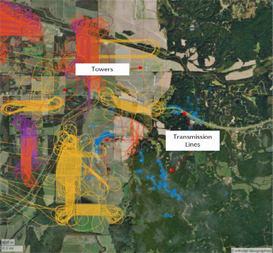
The figure above shows the proximity of ag aircraft working next to obstacles. The color lines represent the flight tracks of ag aircraft while making applications, including the individual spray passes and turns. The lines extending off the image to the left are ferry flights to and from the application sites. The blue circles indicate the location of obstacles taken from the FAA’s DOF (Digital Obstacle File) database and clearly demonstrate the proximity to obstacles within which ag aircraft operate.
NAAA also stated that other manned aircraft besides agricultural aircraft also operate in the 500-foot AGL airspace or below to properly perform their missions, such as emergency medical services, law enforcement, fire suppression, wildlife surveys, powerline patrol and others. These operations occur in a task-saturated environment for pilots due to the numerous existing obstructions, including wires, towers and terrain. BVLOS operations would add to the saturation by concentrating more aircraft in that airspace.
NAAA also stated that the current relatively small size of UAS makes visual detection nearly impossible and referenced the 2015 Colorado Agricultural Aviation Association tests conducted to see if manned agricultural aircraft, both fixed-wing and rotor, could locate a drone over a field. The results were that of four fixed-wing aircraft pilots, only one could locate the UAS and could only do so for a few seconds. The only helicopter, which included a pilot and a visual observer, found the UAS but reported that it was extremely difficult to maintain visual contact. NAAA followed up the point to make the case that it would be perilous for drones not to always be mandated to give way to manned aircraft by stating that for “a low-altitude manned aircraft to visually track a darting … [UAS] while also avoiding ground affixed objects and performing either a policing, application, search, and rescue, etc. task is impossible and a safety hazard.”
An FAA ARC makes recommendations, not policy. The agency takes into account ARC reports and recommendations before proceeding with draft policy. The recommendations from this FAA UAS BVLOS ARC were not unanimously supported. Helicopter Association International, the General Aviation Manufacturers Association, Aircraft Owners & Pilots Association and Air Line Pilots Association voted against the ARC’s recommendations and were just a few of the manned aircraft organizations asked to serve on the FAA UAS BVLOS ARC. NAAA served on the FAA UAS Remote ID ARC in 2017 and co-signed a minority report that urged the agency to require drones from 0.5 pounds or greater to be equipped with remote ID (RID) technology. That requirement was ultimately included in the final RID rule. To read the full NAAA letter to FAA Administrator Nolen, click here.